William FORREST (c1690-c1760): Difference between revisions
| Line 5: | Line 5: | ||
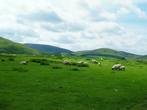
[[Image:West_Calder_Hills.jpg|thumb|300px|West Calder Hills]] | [[Image:West_Calder_Hills.jpg|thumb|300px|West Calder Hills]] | ||
West Calder was described in the early 19th Century as ''“a Parish of Scotland, in Midlothian, 10 miles long, and 5½ broad; bounded on the south by the Cairn hills, and on the north by the Briech, a river which runs into the Almond, at the north east point of the parish. The south part, adjacent to the parishes of Carnwath and Dunsyre, consists of high moorish grounds, interspersed with large marines, and divided into 15 sheep farms which feed about 6000 sheep annually, besides horses. The soil of the arable parts is a black molly earth, or a wet clay on a till bottom. The height is from 450 to 700 feet above the sea level. From this and its vicinity to the Cairn hills, the climate is cold and moist. Agriculture is but little improved. Oats, potatoes, barley, flax, rye-grass, peas, and turnips are the usual crops. The population, in 1798, was 1289 a decrease of 5 since 1755. In the south part of the parish, there are relics of an ancient castle fortified by Oliver Cromwell. Coals and limestone abound, but the former are not wrought, though the proprietor is intending to work them. The inhabitants are very decent, sober, and industrious, quite free from the vices of the metropolis, though so near it.”'' <ref>[Encyclopaedia Perthensis; Or Universal Dictionary of the Arts, Sciences, Literature &c (Volume XXIII 1816) – John Brown#pp192|Encyclopaedia Perthensis; Or Universal Dictionary of the Arts, Sciences, Literature &c (Volume XXIII 1816) – John Brown pp192]</ref> | West Calder was described in the early 19th Century as ''“a Parish of Scotland, in Midlothian, 10 miles long, and 5½ broad; bounded on the south by the Cairn hills, and on the north by the Briech, a river which runs into the Almond, at the north east point of the parish. The south part, adjacent to the parishes of Carnwath and Dunsyre, consists of high moorish grounds, interspersed with large marines, and divided into 15 sheep farms which feed about 6000 sheep annually, besides horses. The soil of the arable parts is a black molly earth, or a wet clay on a till bottom. The height is from 450 to 700 feet above the sea level. From this and its vicinity to the Cairn hills, the climate is cold and moist. Agriculture is but little improved. Oats, potatoes, barley, flax, rye-grass, peas, and turnips are the usual crops. The population, in 1798, was 1289 a decrease of 5 since 1755. In the south part of the parish, there are relics of an ancient castle fortified by Oliver Cromwell. Coals and limestone abound, but the former are not wrought, though the proprietor is intending to work them. The inhabitants are very decent, sober, and industrious, quite free from the vices of the metropolis, though so near it.”'' <ref>[[Encyclopaedia Perthensis; Or Universal Dictionary of the Arts, Sciences, Literature &c (Volume XXIII 1816) – John Brown#pp192|Encyclopaedia Perthensis; Or Universal Dictionary of the Arts, Sciences, Literature &c (Volume XXIII 1816) – John Brown pp192]]</ref> | ||
== Family == | == Family == | ||
Revision as of 11:16, 15 March 2009
The earliest that the FORREST line can currently be traced back to is the late 17th Century with William FORREST of Grange, or Overgrange, in West Calder, Midlothian, who was likely to be born circa 1690.
Origins

West Calder was described in the early 19th Century as “a Parish of Scotland, in Midlothian, 10 miles long, and 5½ broad; bounded on the south by the Cairn hills, and on the north by the Briech, a river which runs into the Almond, at the north east point of the parish. The south part, adjacent to the parishes of Carnwath and Dunsyre, consists of high moorish grounds, interspersed with large marines, and divided into 15 sheep farms which feed about 6000 sheep annually, besides horses. The soil of the arable parts is a black molly earth, or a wet clay on a till bottom. The height is from 450 to 700 feet above the sea level. From this and its vicinity to the Cairn hills, the climate is cold and moist. Agriculture is but little improved. Oats, potatoes, barley, flax, rye-grass, peas, and turnips are the usual crops. The population, in 1798, was 1289 a decrease of 5 since 1755. In the south part of the parish, there are relics of an ancient castle fortified by Oliver Cromwell. Coals and limestone abound, but the former are not wrought, though the proprietor is intending to work them. The inhabitants are very decent, sober, and industrious, quite free from the vices of the metropolis, though so near it.” [1]
Family
The West Calder Old Parochial Records do not give the mother’s name for any of William’s children, and no wills can be found for him that would have provided further information. The records do however show that he had two sons and two daughters as follows,
- i. Elizabeth FORREST, born at Grange, West Calder, Midlothian and baptised on the 24th May 1713[2].
- ii. James FORREST, born at Grange, West Calder, Midlothian and baptised on the 8th May 1715[3].
- iii. Jean FORREST, born at Overgrange, West Calder, Midlothian and baptised on the 12th October 1722[4].
- iv. David FORREST, born at Overgrange, West Calder, Midlothian and baptised on the 17th November 1723[5].
References
[size=80%]
- ↑ Encyclopaedia Perthensis; Or Universal Dictionary of the Arts, Sciences, Literature &c (Volume XXIII 1816) – John Brown pp192
- ↑ Old Parochial Register, Births, West Calder, OPR Ref. 701/0010 0090
- ↑ Old Parochial Register, Births, West Calder, OPR Ref. 701/0010 0093
- ↑ Old Parochial Register, Births, West Calder, OPR Ref. 701/0010 0109
- ↑ Old Parochial Register, Births, West Calder, OPR Ref. 701/0010 0116
[/size]